Further snowfalls expected tonight
6:34 PM Tuesday Aug 16, 2011
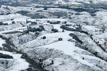 Many areas of New Zealand – including the hills surrounding Wanganui – have been smothered in snow over the past few days. The bitterly cold blast that has hit New Zealand this week should ease off over the coming days, but heavy snow is still expected overnight in many areas, including Wellington and Christchurch. Snow returned to the nation’s capital this afternoon, with a late afternoon surge seeing the the temperature plunge to just above freezing with a wind chill of -5, according to weatherwatch.co.nz
The polar surge in the capital forced police to close roads, including the Rimutaka Hill Road, Wainuiomata Hill Road, Paekakariki Hill Road, and State Highway 58 between State Highway 2 to Moonshine Road and Blue Mountains Road in Upper Hutt. Police said driving conditions were treacherous and people should only travel if it was essential. Extreme caution was needed on all roads in and around the Hutt Valley. Head weather analyst Philip Duncan said the snow will spread across the lower North Island tonight, although some main centres to the north west of the city may avoid the worst snowfalls. “Snow is expected to be heavy around Wellington, Upper Hutt and Wairarapa tonight with a moderate risk of snow flakes returning to low levels of the lower North Island like Wanganui and Taranaki”.
Heavy snow in Wellington is expected to come and go all night with snow easing tomorrow morning. While Gisborne took the national high with 13 degrees today, snow is forecast to move into the Hawkes Bay and Gisborne regions, to 100 or 200 metres.
Polar blast brings snow to downtown Auckland for first time in 72 years…
Read more: http://www.nzherald.co.nz/nz/news/article.cfm?c_id=1&objectid=10745421